The Sacred Altars

Tales of Megaliths in the Mountains

By Mike Blackbird

When my brother Jerry was interested in something, he was totally invested, and his enthusiasm was infectious. In 1979, when I visited him in Idaho from California, where I was living at the time, he had become excited about the prospect of finding megaliths in the mountains of northern Idaho. Jerry was a helicopter pilot, and he intended to conduct an aerial search that summer.

Typically, he’d already done a lot of research, compiling books on the subject, notes, a topographical map, and, crucially, a long article in a 1977 edition of the now-defunct Kellogg Evening News.

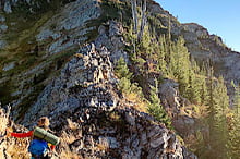
The monuments called megaliths, built of large and heavy stones by prehistoric people, are found throughout the world. Famous examples include Stonehenge in Britain, the Egyptian pyramids, and the megalithic platforms on which the huge human statues of Rapa Nui were placed. Thousands of megaliths span the North American continent.

These radial lines of stone piles, perched rocks, alignments of boulders, standing stones, and slabbed roofed chambers stand in mute testimony to an age of stone in prehistoric America. New England alone has three hundred megaliths, the oldest known structures in the country. There is little or no documentation as to what they were for.

A week after my visit with Jerry, he died in a helicopter crash in the St. Joe National Forest. After his death, I found his megalith materials, which I kept along with his other files, some of them related to his service in Vietnam as a decorated Marine medical evacuation pilot. After the war, he experienced five years of what today would be characterized as post-traumatic stress disorder before rebuilding his life, which included a commitment to public service.

He was elected to the Idaho State Senate, where as a freshman he drafted a major piece of legislation that replaced an arcane method of determining the board feet in a log, which disadvantaged loggers, with a method that would pay them one hundred percent of scale. The bill was passed, and Jerry quickly became regarded as a rising star in state politics. It was then the furthest thing from my mind that one day I would follow in his steps to serve three terms in the Idaho State Senate.

NextGen ScrollGallery thumbnailNextGen ScrollGallery thumbnailNextGen ScrollGallery thumbnailNextGen ScrollGallery thumbnailNextGen ScrollGallery thumbnailNextGen ScrollGallery thumbnailNextGen ScrollGallery thumbnail
Kelly Creek, some miles east of Adair. Araddon photo.
KellyCreekMilesEastOfAdair_Araddon
Site of Adair from Hiawatha Trail. Admiral Hts photo.
OLYMPUS DIGITAL CAMERA
Stevens Peak. Clint Golub photo.
StevensPeak_ClintGolub
The author (left) and brother Jerry. Courtesy of Mike Blackbird.
Brothers
Tunnel at Dominion Creek Trestle. Clark Humble photo.
TunnelAtDominionCreekTrestleNearDominionPeak_ClarkHumble
Kelly Pinnacle site. Google Maps.
KellyPinnacle_GoogleMaps
Kelly Pinnacle is between Brushy Creek and Kelly Creek. Google Maps.
BetweenBrushyCreekAndKellyCreek_GoogleMaps


My wife Florence and I moved back to Idaho in 2013, the year before my book came out, titled, One Flaming Hour: A Biography of Jerry Blackbird. I remembered Jerry’s file on megaliths and thought it was something I’d like to pursue. I went to his papers but discovered to my dismay that I had misplaced the file.

That was the end of it until last year, when I was looking for a piece of information in my library and picked up an Idaho atlas. Opening it, I found the lost 1977 newspaper article. His notes and the topographical map he had used were still missing, but I did have his collection of books on megaliths.

Among them are: Francis Hitchings’ Earth Magic: The astounding mystery of the greatest of all lost civilizations (William Morrow, 1977), Salvatore Michael Trento’s The Search for Lost America: The mysteries of the stone ruins (Contemporary Books, 1978), and A. Thom’s Megalithic Lunar Observatories (Oxford University Press, 1970).

The books taught me much about megaliths in America and beyond our shores, but the decades-old Kellogg Evening News article, by feature writer Jeanette Young, was the main treasure. Reading it, I reflected that I would have loved to roam the steep Bitterroot Range in search of megaliths that might provide evidence of an ancient civilization, but this was no challenge for an octogenarian to undertake. Instead, I devoted my efforts to trying to pinpoint their likeliest location, if indeed they were anywhere.

Jeanette, who is no longer alive, had found a man in Wallace named Sam Peterson. He recalled that when he was eleven or twelve years old, which I believe would have been in the 1920s, he liked to hike with his elders to what they called an “ancient city” located on a high plateau covered in bunch grass. From it, they could see Montana.

These hikes started in Sam’s hometown of Adair, a small Bitterroots railroad community on the Milwaukee Road Railway that no longer exists and has left little evidence that it ever did.

Sam couldn’t remember exactly where the plateau was, but he said you could tell something had been there. He recalled large donut-shaped stones with holes in the center that lay in a streambed. It was a rushing spring, even though the elevation was quite high. Reading this, I surmised that it might have been the headwaters of Manhattan Creek, which runs from the base of the round-topped Dominion Peak past Sam’s old hometown of Adair.

Jeanette also had uncovered two 19th Century accounts of ruins somewhere on the Idaho/Montana border in the Bitterroots, which could be near Adair.

The first article was published July 30, 1887, in the Wallace Free Press. It said that in 1883, a clearly marked trail crossed the South Fork of the Coeur d’Alene River near the town of Mullan, and ascended the range of the St. Joe Divide, across from the main Bitterroot Range. This would be in the general direction of Adair but the hiker apparently traveled about twenty miles westward before coming upon ruins on level tableland.

Two moss-covered walls of a time-eaten structure of hewn stone remained above the earth’s surface. The foundation was in a reasonable state of preservation and the walls were about two feet thick. The structure appeared to have been an oblong of about thirty-four by forty-eight feet. Outside the walls were a series of earth-covered, well-rounded mounds and in the center of them was a circular structure made of hammer-dressed stone that the unnamed observer supposed was a place of worship.

The article said the most likely location of this site was near the Monument Mine. I found no historical evidence of such a mine, although there was a Monitor Mine in the Adair area. It was a copper mine and, interestingly, megaliths predominated during the Bronze Age. For example, the Egyptians built their massive temples and pyramids using wooden mallets and bronze chisels.

The second article was written in 1890 by William Herndan Frazier for a publication out of Portland, Oregon, called West Shore. The headline read: “Sacred Altar: A Mullan man finds them in the St. Joe Mountains.” Frazier reported, “Perhaps one of the most interesting objects of a prehistoric race is the sacred altars, about fifteen miles southeast of Mullan, in an unfrequented spot beyond the lofty peaks of the St. Joe range of mountains.

“It is a day’s journey of many hardships. As you wend your way  over the old mining trail and through a labyrinth of foliage and downed timber, you wonder how the aborigines or clans of prehistoric men ever sought this place to build the monuments to the gods of these people.”

He continued, “It’s a wild, weird spot; the sparkling waters of a tributary of the St. Joe River make nature’s music at the base of the mountain, and St. Steven’s Peak, the highest point of the Coeur d’Alene Mountains, lifts its snowcapped head high above the ‘round top’ of past worship and sacrifice.”

There is no St. Steven’s Peak but there is Stevens Peak, about two-and-a-half miles south of Mullan. It’s neither in the contemporary St. Joe Mountains nor the neighboring Clearwater Mountains, both of which belong to the Bitterroot Range, but it is the tallest mountain in the western part of the main range. I thought Frazier’s reference to a “round top” might coincide with the other historical account if it was the treeless Dominion Peak, north of Adair and the Monitor Mine on the Idaho/Montana border.

He rhapsodized that “the morning sun kisses the chapel of the past through a pass in the Bitterroot rand [an obsolete term that means “border”] and leaves its last light dancing on these pyramids of unknown gods. Of these sacred altars, there are six in number, built of basaltic rock taken someplace beyond a hundred miles from this point, as there is no rock of this character in the vicinity, and of a particular masonry unknown and unrecorded in the history of the craft…They are seven feet in height.”

The nearest basalt is found around a hundred miles away, in eastern Washington near Spokane. The entrance to the contemporary Spokane Airport is bordered by columns of basalt, many of them seven feet tall. I noted, however, that Sam Peterson had told Jeanette he didn’t remember seeing any basalt on the plateau he had visited as a boy.

Frazier’s account continued, “Within the distance of an arrow’s flight of the altars is a square amphitheater, which seems to have been hewn from solid rock and worn almost as smooth as polished marble…Outside of the immediate surrounding, there is no sign of man in the glen’s canyons and mountains of the vicinity.”

The solid rock worn smooth as polished marble conjures the granite composition of the Bitterroots. Frazier concluded that nobody would ever solve the mystery of who built the monoliths or why they were constructed. He made the leap of faith that “sometime in the distant past, a race of people existed here who communed with gods of high art and enjoyed a civilization equal, if not superior to our own.”

Armed with a topographical map, I questioned my good friend John Specht about his extensive travels over the region. John, who is retired from the Forest Service, knows the Bitterroots well. He has hunted the area for more than sixty years, and I figured he would be the perfect megalith source.

Dominion Peak, of course, was the place that interested me most. The Bitterroots are generally heavily forested, steep up-and-down country, but that isn’t true of Dominion Peak. John had hiked to the top of the peak, which he told me isn’t a plateau. He had found the footings of a Forest Service lookout there, but no evidence of megaliths.

So much for Dominion Peak.

I turned to a couple of other nearby locations I had circled on the topographical map. It appeared there were two possible plateaus between Manhattan Creek and Kelly Creek, uphill from Adair. Perhaps one of these creeks was the “sparkling waters” tributary of the St. Joe River that Frazier had described in his article.

John had hunted both sites. He said neither one was a plateau, but then he gave me an intriguing clue. He said Kelly Pinnacle, in the same area but between Kelly Creek and Brushy Creek, was a plateau that had been burned over in the huge 1910 fire that devastated much of the region. Since then, regrowth had heavily forested it. If the megaliths were there, John said, they wouldn’t be readily visible.

While it seems unbelievable that people in any age would undertake the task of moving heavy basaltic pillars over great distances, especially to a site high on a rugged mountain, consider the story of Stonehenge, built about four thousand years ago.

Massive bluestones were floated and dragged more than one hundred miles from the Preseli Hills in southern Wales to construct Stonehenge. The pyramids of Egypt are another example of seemingly impossible ancient constructions.

Even the steep terrain of the Bitterroots might have been overcome by ancient builders such as those who made the medicine wheel in north-central Wyoming near the crest of the Bighorn Mountains, at an elevation of 9,642 feet. The medicine wheel is a large ring of stones filled with radiating stone lines. Made of local white limestone laid upon a bedrock of limestone, it has been visited by tribal people for nearly seven thousand years, and there are others like it scattered across the northern plains of Wyoming, Montana, and Canada.

Ground-penetrating radar has uncovered a number of ancient Mesoamerican Mayan and Aztec ruins, but how much would that technology cost? Better for contemporary explorers to don their hiking gear and have a close look at Kelly Pinnacle. Any takers?

If you enjoyed this story, please consider supporting us with a SUBSCRIPTION to our print edition, delivered monthly to your doorstep.


This content is available for purchase. Please select from available options.
Register & Purchase  Purchase Only
Mike Blackbird

About Mike Blackbird

Mike Blackbird was born at Wardner Hospital in Kellogg in 1942, graduated from Kellogg High School, served in the Navy from 1960-1964, and graduated from the University of California, Long Beach in 1969 with a degree in history and political science. He represented Idaho’s five northern counties in the Idaho State Senate for three terms, 1986-1992. Mike, who retired in 2009 as regional sales manager for a health products and services provider, has two children with his wife Florence.

Leave a Comment

Your email address will not be published. Required fields are marked *