No products in the cart.
All along the Rim
Into the Unknown
Story and Photos by Mike Cothern
The author, a longtime IDAHO magazine contributor, got an idea a while back to hike the entire canyon rim above Salmon Falls Creek, which runs primarily through the high desert of southern Idaho to its source in the remote Jarbidge Mountains of Nevada. He wrote a book about the adventure titled, Searching Salmon Falls. In this excerpt, published with permission, he describes a visit to the Balanced Rock area above the creek, during which he concocted his plan for a series of exploratory hikes. Here, Mike continues his ascent beyond the landscape’s main attraction.
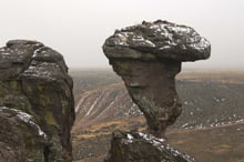
After my pause underneath Balanced Rock, I scramble up several more slabs of wet stone and reach a vantage point not quite a hundred feet beyond the landmark. The spot puts me nearly at eye level with the top of the stone and provides an ideal position from where to photograph its silhouette. I most often arrive near sundown and hope for a background sky that harbors a few clouds that might blossom into a palette of colors. The best opportunity comes near the winter solstice, when the sun sets at its farthest point south. Usually nothing much happens except for me becoming chilled, but when everything comes together the visual transcends the cold. On this overcast morning, however, the flat light offers little to work with. The camera stays in my pack and I walk away. Exploring sounds like a more rewarding option.
I gain more elevation and then wander along the tops of other towers that stand in a slightly curved line near the road as it drops into the canyon. That same process responsible for shaping the area’s most popular resident also deserves credit for the creation of most all the rockwork in the vicinity—including those profiles that mesmerized me during last week’s meander through the park. To understand how all this came to be, I consulted with Shawn Willsey, a geology professor at the College of Southern Idaho. He has enlightened me numerous times about the region’s landscapes and possesses that knack for summarizing an idea with just enough terminology to make you feel enlightened, rather than dizzy [see Shawn’s story, “A Shocking Impact,” IDAHO magazine, September 2017].
Before we delved into the actual sculpting process, Shawn wanted me to first understand why the erosive rhyolite was present. I had seen plenty of the neatly layered, gray basalt upstream—why did this random jumble of brown rock show up here? Shawn pointed out that in the middle of the Snake River Plain, rhyolite is almost always older and therefore lies underneath the stacks of basalt. With the Balanced Rock area being far enough away from that central zone, however, the basalt flows here sometimes ended up being not as thick. In addition, he asked me to visualize the underlying rhyolite as not being a horizontal, level surface. In this location the lava production left a high point. The subsequent, thinner basalt flows then could only lap around the edges of that elevated terrain.
This content is available for purchase. Please select from available options.
Register & Purchase Purchase Only
Register & Purchase Purchase Only
