No products in the cart.
What Lies Beneath
Under, Around, and Before Dworshak Dam
By Richard Thorum
In August 2017, when I took a job as a park ranger at Dworshak Dam south of Lewiston, I’d never journeyed in Idaho north of Boise. I grew up on the outskirts of the Great Salt Lake, in what was once called the Great American Desert, six hundred miles by road south of Dworshak. Most of my life had been spent in the red rock country around southern Utah and the Grand Canyon. The job offer came as a welcome surprise and challenge. I was sixty-six, and had left government work some time ago for other pursuits. (The following summer, Ranger Magazine published an article about my return at that age.) I must say, I was awestruck upon seeing the massive dam for the first time. Two other things also caught my eye: the seemingly endless forest around the lake and the abundance of ancient rocks.
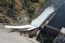
On the North Fork of the Clearwater River, by the towns of Ahsahka and Orofino, Dworshak Dam has a structural height of 717 feet, which makes it the third-tallest dam in the United States. The 770-foot Oroville Dam in California is first and Hoover Dam is second at 726 feet. Dworshak also has the distinction of being the highest straight-axis dam in the western hemisphere. A straight-axis dam doesn’t curve, it’s straight across. At Dworshak, it’s three-quarters of a mile across. Its concrete volume of 6.5 million cubic feet makes it by far the largest dam construction project the Corps of Engineers has ever completed.
This content is available for purchase. Please select from available options.
Purchase Only
Purchase Only
