Blog Archives

An Idaho Love to the End

Posted on by William Studebaker / Leave a comment

Nearly seven months have passed since Dad died, and now a white box about 11” x 5” is squeezed between books on the bottom shelf of my bookcase. For Dad, that’s borderline ignobility. To be as a book or a bookend, well, if he knew, he’d grind his silica.

You see, he can’t turn over in his grave. He’s in that box. He’s been cremated, and a cremated person, as the mortician explained to me, isn’t really ash; rather he’s silica.

Mom’s been living alone since Dad died. She’s taken widowhood in full stride. I suppose there must have been lonely hours, but she scrubbed the house. She washed all the curtains. She cleaned the car. She tidied up the yard, and she kept me and my sister busy reaching for and pounding on what she could not. It’s been grand because Penny and I thought she might fall into depression or trip over grief.

For the last several years, Dad didn’t like to get more than a short gallop from home. Now Mom’s able to jump in her car, zoom to Payette and visit her brother (who’s in a care center) and sister-in-law whenever she wants. Now that’s a joy. That’s as much fun as playing bingo or pinochle at the senior center.

Senior center! You’ve got to be kidding me. I never thought my mother would be out socializing, partying it up, going out for lunch, or buying raffle tickets. She’s even jumped on the bus and spent a senior citizen’s evening in Jackpot, Nevada. Continue reading

It Came From the Deep

Posted on by Bill Adams / Leave a comment

When I was in high school, my friend Hank and I used to go the Boise YMCA occasionally to use the pool. Hank was a talented diver and spent his afternoons practicing new dives while I stuck to cannonballs and belly flops. Trouble always seemed to follow Hank. On more than one occasion he cracked his head open with his own knee while doing back flips into the pool, forcing me to take him to the emergency room. One day, however, Hank managed to dive without incident, so after our swim we decided to take a whirlpool.

Hank always bragged that he could hold his breath longer than I could, so we decided to have a breath-holding contest. I went first. After just a minute I had to come up for air. Then it was Hank’s turn. He took a huge inhalation then plunged beneath the foamy surface of the water, disappearing completely. I sat at the edge of the pool watching the clock.

Thirty seconds…forty…a minute… The bubbles bubbled, but Hank did not surface. A minute twenty… a minute thirty… still, no Hank. Continue reading

Steam Days

Posted on by Linda J. Henderson / Leave a comment

“Oh yes!” he says wistfully, “They have a distinctive sound, and they talk to you. That steam would go into the cylinders and dissipate out through the stack, and that was a sound that you never forget.”

That is how Harlan “Toad” Turner describes running a steam engine when he was a young man working on the legendary Camas Prairie Railroad. Now eighty-four, he still has the frame of a big, strong man. As he reminisces, he waves his brawny hands in the air as though he were still moving the Johnson bar and adjusting the dampers.

Harlan earned his nickname as a youngster. After hopping through a barbed-wire fence with a bunch of his friends, one of them said, “Why, you jumped through that just like an old toad.” The name stuck, he says, and his wife Neva says she has to use the nickname in the phone book or his friends can’t find him.

Now retired, Toad loves to talk about his “railroadin’ days.” He started out in 1944 as a young man shoveling cinders out of the pits at the roundhouse in Lewiston. From there he moved up to clerk in the station at Spokane. A fellow had to wait for an opening in those days, as the ones with seniority got their pick first. Finally there was an opening for a switcher, then for a fireman, and Toad moved up. But he wanted to run those engines. Continue reading

Digging Up the Past

Posted on by Steven Branting / Leave a comment

Graveyards are traditionally permanent, inviolate resting places deserving of community care. For various reasons, however, some cemeteries have needed to be exhumed and transferred to new land. In 1888, Lewiston found itself in just such a predicament as the town began to stress its original boundaries along the Snake and Clearwater Rivers, the spring floods of which repeatedly destroyed property and hindered business growth.

Lewiston’s cemetery was the stereotypical “Boot Hill,” a plateau above the town where interments had been performed since the early 1860s. Regrettably, the eight-acre site was increasingly perceived as an impediment to civic “progress,” its proximity to the future neighborhood of the town’s wealthiest families considered undesirable. The cemetery’s disturbing lack of upkeep and state of disrepair aggravated the situation. Cows roamed freely among the graves, trampling wooden and stone markers. The stately, whitewashed fencing installed at great expense in 1879 was now drab, decayed, and falling down. The cemetery had become an eyesore, not what one would expect of an emerging shipping center and the site of the Pacific Northwest’s first telephone service.

After several proposals were debated and discarded by the city fathers, a new forty-acre site was selected in an area deemed to be distant enough from the town’s center to pose few problems for city developers. In December 1888, the city council officially banned any further burials in the old cemetery, and in the spring exhumations began. The platting records were woefully inadequate. Indeed, no map of the original cemetery has ever surfaced. By May 1893, the city council was obligated to “devise ways and take necessary steps” for removing the remaining graves and quickly passed an exhumation ordinance, contracting with Dudley Gilman “for the removal of the dead from the old city cemetery.” His costs were to be passed on to the surviving family members. Since he was related to a popular former mayor, no one openly questioned Gilman when it came time to pay his bill—$752.30 for no more than a few days’ work. Later that year, he was authorized to plow and harrow the grounds, taking the more than seventeen hundred feet of cemetery fencing as payment.

However, apparently the city council was not satisfied that every body had been removed. A brief notation in the city council minutes of the May 6, 1895, proclaimed: “It appearing to the satisfaction of the Council that certain persons were buried upon lands owned by the City…the Marshal was ordered to notify the interested persons to remove such bodies at once to the new Cemetery of the City.” The “interested persons” were none other than long-time residents and influential Jewish businessmen Abraham Binnard and Robert Grostein, who had been resisting the exhumation ordinance for nearly two years. But more about that later.

That same year surveyors divided the old cemetery property into four lots for potential sale, but plans for a new hospital, church, and Masonic Temple came to nothing. By 1900 a major portion of the grounds had been dedicated for use as Lewiston’s first municipal park. In 1905 a new Carnegie Library opened, and the Idaho Supreme Court Library was erected. Trees were planted throughout the park. In 1911 a local women’s group spearheaded the construction of a large fountain—complete with a statue of Sacajawea—in time for a speech by President Howard Taft from the park’s band shell, the only time a sitting president has visited Lewiston. The site of the old cemetery had been transformed, its legacy obscured by the circuitous paths of community development.

Adding to the usual graveyard mystique, a persistent story circulated that a mass grave had been dug in the new cemetery (now known as Normal Hill Cemetery) when the unidentified remains from the old burial lots had been gathered and transferred to the out-of-the-way unmarked site. A current lot map shows most of an entire row with the penciled annotation “NR,” which has long been assumed to mean “no room” or “no record.” It would take a group of dedicated students and some space age technology to unmask a truth more interesting than anyone imagined.

As a consultant for gifted programs, and a cartographer for the Lewis-Clark Rediscovery Project, I decided this forgotten cemetery would be a perfect puzzle for my class of seventh-grade students at Jenifer Junior High School. Using geographic information systems (GIS) with the popular software ArcView, we set out to uncover the truth behind the mass-grave rumor. Continue reading

Take the Pend Orielle Plunge

Posted on by Dianna Doisi-Winget / Leave a comment

August 10th, 2003, dawned clear and beautiful, promising to be yet another of the many memorable days of that summer when the mercury inched into the nineties or beyond. From my supreme vantage point atop Sandpoint’s picturesque Long Bridge, I could feel the restless excitement of the swimmers on the beach below as we all awaited the beginning of the ninth annual Long Bridge Swim. Soon came the deep bellow of the air horn and over three hundred eager bodies surged into the chilly, but pristine, waters of Lake Pend Oreille. Not just another race, the event has become the Northwest’s premier open water swimming event, attracting participants from all over the western United States.

What makes this 1.7 mile swim so special? Several things. First and foremost is the attraction of Sandpoint itself. Long famous for its lakes, mountains and rivers, this little town of seven thousand also has established itself in the fields of music, art, and culture. But what really makes the Long Bridge Swim unique is the Long Bridge itself—actually two bridges side by side, one for traffic and one a pedestrian/bike path—which offers unsurpassed spectator viewing. After all, how many open water swimming events are there where you can stroll along with the swimmers every step of the way? And what a stroll it is.

Bridges have been a part of Sandpoint’s history for over 120 years, since the Northern Pacific Railroad built the first railroad bridge in 1882, connecting the area to the East and establishing Sandpoint as a bustling mining and timber town. And while mining and timber no longer claim as big a piece of the economic pie, there are still plenty of bridges. In fact, no matter from which direction you approach Sandpoint, you have to cross a bridge.

Anyone who enters Sandpoint from the south on Highway 95 will cross Lake Pend Oreille on the Long Bridge. The view alone has convinced many individuals to make this beautiful North Idaho community their home. And no wonder, with the lake’s clean waters beneath you and the jagged Cabinet Mountains rising against the sky to the east, it’s a view not quickly forgotten. To the north and west, rising sharply behind the town, is the Selkirk Mountain range with backcountry wilderness stretching some sixty miles to the Canadian border. Continue reading

The “23”

Posted on by Will Edwinson / Leave a comment

What made this part of Black Canyon unique was the canyon bottom. Standing at the rim of the canyon wall a hundred feet above the river, one could view a piece of God’s artwork at its best. The canyon bottom was formed by molten lava that had flowed, and later hardened, to form a flat surface similar to that of a giant patio. This patio-like canyon floor was approximately a mile and half long and five to six hundred feet wide. Scattered along this giant patio were several large holes that made up the various pools of water where Buddy and his friends enjoyed swimming. They varied in size from twenty-five to forty feet across.

There was a larger pool just down river from the 23 called the “60,” and though the boys swam there also, the 23 was still favored because it was somewhat smaller, which enabled the sun to heat the water to a warmer temperature. Because the water flowed so slowly through this section of Black Canyon, it was nearly stagnant. Not so stagnant that it became foul, but stagnant enough that the sun was able to heat some of the pools to a near tepid state.

Buddy was standing waist deep in the pool on a rock ledge about three feet below the surface of the water. It was about thirty feet across the pool and Buddy wondered if he could make it to the other side. He had mastered the dog paddle pretty well, but he had only dared venture a few feet from the safe haven of the edge of the pool. Although he felt he was ready, he had never mustered the courage to attempt a crossing. Today, he thought, is the day I should try it. Continue reading

Father

Posted on by Ginger Beall / Leave a comment

I never speak to my father. Stern, gruff, and ancient at the age of sixty-three, he terrifies me. He growls that we are no good, gives us orders, and swaggers around half-lit on homemade wine, telling of the rough work he does at the sawmill each day. I want him to like me, but I am just a skinny little girl. I can’t chop wood or milk the goats, like my big sisters. Our pigs and the dark scare me to death. I only do one thing really well, and that is spell.

In my second grade class at Weippe Elementary School no one spells better than me. That’s why I‘m going to Orofino for the district-wide spelling bee. Because I placed first in all the contests held at our local school, my teacher told me I had earned the privilege and responsibility of representing Weippe in the district competition. I’m nervous, but I tell myself I can outspell everyone in the big town of Orofino. Neither of my parents has ever attended any of my spelling bees, but Daddy agrees to drive me to this event. He decides that Mama will come with us. Such special attention makes me feel giddy.

Mama braids my hair up tight in long French braids, telling me she’s so proud of me. I put on my best dress, a red calico with short puffy sleeves and two layers of gathered ruffles for the skirt. Mama dresses up too, in her Sunday clothes and shoes. Instead of his usual work shirt and jeans, Daddy puts on his navy blue pinstripe suit that only gets worn when there’s a potluck at church and he goes with us to get something to eat. He warms up the old green truck and I climb in to sit between my parents for the winding descent on the Greer hill from Weippe to Orofino. Continue reading

Thirty-Six Hours in Idaho

Posted on by Brendan Leonard / Leave a comment

Most Idaho travel brochures won’t tell you that in just two days’ time you can see lava that came from thousands of feet beneath the surface of the earth, a legendary writer’s last resting place six feet beneath the earth, and stand 12,662 feet above the earth. But that’s just what my friend Tim and I set out to do last July.

I had spent most of my summer working at the Post Register in Idaho Falls. Although my internship had lasted three months, I didn’t feel that I knew any more about Idaho than before I came. (Though I could find Rexburg, INEEL and Blackfoot on a map).

Tim and I had two days to see Idaho, so we left Idaho Falls on a sunny Wednesday, shooting west down Highway 20. First stop, Craters of the Moon National Monument.

We turned off the highway and followed the loop that cuts through the monument. I tried to keep my eyes on the road but ended up staring out the window at the endless lava fields peppered with sagebrush.

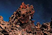
The name “Craters of the Moon” was no coincidence. The entire preserve actually looked like the surface of a barren planet. It was a strange sight in the middle of scenic Idaho, a state I thought was famous for its mountains, valleys, streams, and lakes, not a giant magma wasteland.
Tim and I hopped out of the car at the foot of Big Cinder, the monument’s largest volcanic cone. We crunched our way up the massive black mound and I remembered my high school track days, running hundred-meter dashes on cinder tracks.

“You know, if you jump up and down on this stuff, it feels exactly like jumping on snow,” Tim said, snapping photos of the landscape.
“Yeah?” I said. I immediately began hopping and stomping like I hadn’t done since I was ten years old. It didn’t feel like snow, but there was an odd bounce to it, pushing me back up when I landed. Up and down, up and down, bouncing until I felt embarrassed.
We stood at the top of Big Cinder and gazed over the scenery below: brown and black lava fields and cinder spread over the land where the greens and browns of grasslands should have been. I thought I knew what natural beauty was—the rugged upward juts of mountains, ocean waters rolling on the horizon, the dramatic curves and drops of canyons and gorges. Craters of the Moon was just, well, beautifully strange.
I wasn’t the only one to think so. In the 1924 presidential proclamation that established it as a national monument, Craters of the Moon was called a “weird and scenic landscape peculiar to itself.”

Considering it was midweek, I was surprised to see several other visitors at the monument, driving around the loop and hiking up the cinder cones.

“Most of our visitors are just passing through,” Jim Morris, Craters of the Moon superintendent, says. “We’re between Yellowstone National Park and the Sawtooth Recreation Area. People pick Yellowstone as a destination vacation spot, and they’ll stop here on their way through.”
Two hundred thousand visitors stop at Craters of the Moon every year, and Morris estimates sixty percent of them don’t pick the monument as their “destination” spot.

Tim and I didn’t either. We hopped back in the car and took off down Highway 20 again. Next stop, Ketchum.

When we arrived in Ketchum’s surprisingly cosmopolitan downtown we were instantly surrounded by luxury SUVs and the summer resort crowd who could afford to drive them.

We knew what we had to do. We walked into the Sun Valley/Ketchum Chamber and Visitors Bureau to find out where Ernest Miller Hemingway was buried. Armed with directions to the Ketchum city cemetery and, more importantly, directions to Hemingway’s grave (back row, near the middle), we bolted out the door and sped onward.

At the cemetery, we found Hemingway’s headstone next to that of his fourth wife, Mary Welsh Hemingway. Hemingway’s grave was littered with coins, like a dry wishing well. Tim and I briefly considered collecting the change and using it to pay for our lunch.

“I think if he was still alive, he would have at least bought us a drink,” Tim said.
“You know, I don’t think it’s a good idea,” I said.

We took turns standing near the headstone and taking each other’s picture, proof that we’d been closer to Hemingway than anyone else we knew. Even if he was dead, I thought, paying my respects might bring me some good luck as a writer.

We saw no one else in the cemetery, but we weren’t the only fans who were curious about the grave. Laura Hall, information specialist at the Sun Valley/Ketchum Chamber and Visitors Bureau, says five to seven people come into the visitors bureau every day during the summer to ask about Hemingway.

“The majority of requests for Hemingway are from our male visitors, from college-age all the way up to sixty,” Hall says. “This was his very private place. He never wrote much about it—this was his American getaway.”

Hemingway wrote For Whom the Bell Tolls in suite number 206 at the Sun Valley Resort in 1939. After we visited his burial site, the only item left on our itinerary was our ascent of Borah Peak. I was excited, but infected with a nervous fear of the mountain—I didn’t want to know for whom the bell tolled; it was tolling for me.

Borah Peak, at 12,662 feet, is the highest point in Idaho and pops into the sky along Highway 93 about thirty-three miles south of Challis. As we drove toward the peak, the late afternoon sun painted the trees and valleys in a warm light and took my mind off the next day’s climb until we hit the dirt road leading to the Borah trailhead.

My car rattled over the bumpy road and Borah sat with its head nearly blocking the sun, laughing at us. We set up camp at the trailhead and slept fitfully until just before daylight.

We hiked up the steep trail in the shadow of the mountain, starting at an elevation of 7400 feet. Over the 3 1/2-mile climb, we would gain nearly a mile of elevation. As we pushed on past the treeline, the sun came up over Borah and lit the valley below. Even from where we stood, only halfway up the mountain, the view was spectacular. Deep green circles from irrigation sprinklers hung between ribbons of streams cutting across the valley floor, flat and what seemed like forever away from us.

We stopped for a quick change of clothes after the sun came over the mountain, then pushed on up the ridge. It was a comfortable climb until we met the boulders that mark the beginning of Chicken Out Ridge. From there, we scrambled up and over, trying not to look down on either side, each offering vertical drops one of my co-workers had warned me were “a quick exit off the mountain.”

The last bit of Chicken Out Ridge drops onto a snowfield traverse of about sixty feet to the other side. In celebration of my successful negotiation of Chicken Out, I chicken-danced across the snowfield.

No one laughed.

“Don’t get cocky,” a climber on the other side warned. I was definitely not funny.

The snow crossing behind us, we climbed what felt like straight up a never-ending mess of rocks to the summit. I stood at the top and looked at a 360-degree panorama of peaks: The Lemhi Range, the White Cloud Mountains, the Boulder Mountains, the White Knob Mountains, the Sawtooth Mountains, the Salmon River Mountains, and the Pioneer Mountains, all packaged together in a view that can only be seen by flying or by climbing.

We had reached the summit in a little less than five hours, taking about the same time as the many other climbers we saw that day.

“If you don’t mind the people, Borah is a nice climb within the reach of most advanced hikers,” Jerry Painter, co-author of Trails of Eastern Idaho says. “Summer weekends can be fairly crowded. If you go in the off-season (late September to early July), Borah is a serious mountaineer’s challenge. That’s when you find out it’s a real mountain. In the summer, it’s a kitty. In the winter, it’s a tiger.”

After three hours of running downhill from the summit, we arrived back at the trailhead. We threw our packs in the car and started the drive back to Idaho Falls.

We finished our journey in less than thirty-six hours, and we had worked in as much as we could as fast as we could. We saw the Craters of the Moon, stood next to the grave of a literary star, and got as close to the sun as we could get in Idaho. If the Gem State bordered the ocean, we probably would have taken a dip in that too. But instead we settled for a couple of well-deserved showers. Continue reading

A Town To Be Proud Of

Posted on by Arthur Hart / Leave a comment

Mountain Home was in its infancy when this photograph was taken about 1885. The freight wagon in the foreground, hitched to an eight-mule team, looks a lot like one of the covered wagons that carried pioneers over the Oregon Trail.

Wagons like these passed north of present Mountain Home on the great Overland Road bringing pioneers into the Pacific Northwest. After the Union Pacific railroad was finished in May 1869, freight from Kelton, Utah, was hauled along the old route, known thereafter as the Kelton Road. It connected the Union Pacific with mining towns in Boise Basin like Idaho City, Placerville, and Boise City—capital of Idaho Territory. Rattlesnake Station on that road, where Rattlesnake Creek comes out of the mountains, was renamed Mountain Home, no doubt because it was a prettier name, but also because it was near Bennett Mountain Continue reading

Rosalie Sorrels

Posted on by Kitty Delorey Fleischman / Comments Off on Rosalie Sorrels

Mellifluous. The word could have been coined especially to describe Rosalie Sorrels’ voice. Whether singing, or storytelling, the word fits. For days I’ve sought other, simpler words, but the search for vocabulary always dissolves to images. For Rosalie, speaking and singing are one. It’s how she communicates.

In her voice is the sound of Grimes Creek dancing over rocks and nudging flecks of gold along the course of its laughing waters. Then sometimes you’ll hear the gravel that lines the creek bed. You hear the trilling songs of birds that sail bright skies in her mountain sanctuary, and the shusshing sway of pine branches fluffed by breezes that sing to the cabin her father built by hand early in the last century. Sometimes you’ll catch a momentary glimpse of the sharp edges of rocks lining the canyon walls.

She came by it naturally as part of a well-read family of people who also loved to sing. As she talks, she switches from conversation to poetry to song in a smooth flow. In 1999 Idaho’s songbird also was chosen for a Circle of Excellence award from the National Storytelling Network.

For more than a half-century, Rosalie Sorrels has taken the sounds and stories of Idaho across the continent and beyond the seas. Jim Page, a folksinger from Whidby Island, Washington, once described Rosalie as “the most real person in folk music that I’ve ever met.” Now past her seventieth birthday, her outlook on life is both broader and narrower than it was when she was a younger woman. She has traveled extensively and has seen the world, yet the greatest treasures of her life are her family and her little handmade Grimes Creek cabin.

Her mother named the cabin Guerencia, which means “the place that holds your heart.” It’s a snug cabin with posters of her heroes on the ceiling so she can look up at them when she is in bed. The cabin’s walls are lined with books stacked layers deep on shelves, all of them read and all remembered.

As a youngster, Rosalie’s father gave her a dollar for each “chunk” of poetry she learned. She earned three dollars for learning Sir Walter Scott’s “Lady of the Lake.” When other youngsters were learning nursery rhymes, Rosalie learned to quote Shakespeare. Continue reading